
Research Methodology Sample Work
Dam site selection using GIS and REMOTE SENSING for decision making support in in northern Somalia
Info: 2021 words Sample Research Methodology
Published: 14th DEC 2022
Tagged: Engineering & Technology
A case study of Upper-Biji Catchment sub-catchment of Gulf of Aden Basin in northern Somalia . The authors incorporated AHP Multi-Criteria Decision Analysis to choose potential dam sites within a GIS system.
3.1 Data Collection
A number of datasets were used in this investigation. These criteria, which include DEM, soil type, geology, land cover, and rainfall and have an impact on choosing a dam site, were used to derive the pertinent data. They are discussed below.
3.1.1 DEM
Shuttle Radar Topography Mission (SRTM) 1 Arc-Second Global imagery with a 1-arc resolution was used to produce the DEM for the Upper-Biji Catchment. It was downloaded from the United States Geological Survey (USGS) website. The project area's drainage network and slope maps, which were made using the Upper-Biji Catchment DEM, were used to choose the best locations to erect sand dams. Generally speaking, SRTM is the most significant source of elevation data. Digital elevation data for the entire planet with a resolution of 1 arc-second has been produced using updated SRTM data to fill in missing data gaps (USGS, 2021a).
3.1.2 Soil
The International Union of Soil Science (IUSS) proposed the creation of soil maps for continents and important regions during its Seventh Congress in Madison, Wisconsin, in 1960. As a result, FAO and UNESCO created a 1:5 000 000 scale World Soil Map in 1961. It took twenty years to finish the project in its entirety. It was the outcome of an international collaboration of numerous soil experts, and up until recently, it was the sole global overview of soil resources (FAO, 2021).
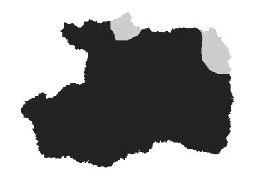
Figure 1:
3.1.3 Geology
The geology for the Upper-Biji catchment was acquired from the USGS Globe Energy Project in 2000. The study area of the Upper-Biji watershed was trimmed and used by the shape file of the Upper-Biji catchment, which was created from the data obtained as a shape file for the complete Africa geology map (USGS, 2021b).
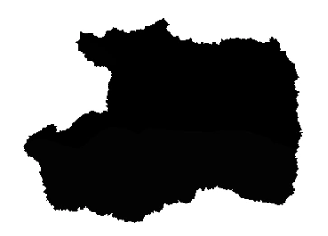
Figure 2:
3.1.4 Land cover
With a resolution of 100 meters, a land cover map of Somalia was produced in 2019 using data from Copernicus Land Cover Map (Copernicus, 2021).
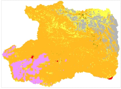
Figure 3:
3.1.5 Rainfall
For the Upper-Biji Catchment, average annual precipitation data were obtained using the Climate Hazards Group Infrared Precipitation with Station Data (CHIRPS Daily) dataset, which spans 20 years from 2000 to 2020. In-situ data from stations are used to build a gridded precipitation period sequence by the CHIRPS imaging satellite, which has a resolution of 0.05°. This is done for drought trend analysis and seasonal monitoring (Earth Map, 2021).
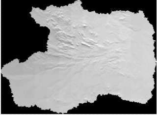
Figure 4:
3.2 Multi-Criteria Analysis in Dam site selection
Multi-criteria analysis is a method of selecting options when there are many distinct sorts of factors, some non-tangible and some cost variables. As part of a traditional cost-benefit analysis, several facets of each alternative are given a monetary value. Problems arise because people's perceptions of worth vary, and it is challenging to determine an exact price in areas like the environment and social implications. The multi-criteria analysis technique was created to evaluate possibilities without giving them a monetary value. However, some elements of each study can be appropriately valued in terms of cash costs and benefits, which multi-criteria analysis can incorporate into the entire analysis (Dortaj et al., 2020).
Although losses in terrestrial ecosystem diversity were noticed, mainly as a result of the dam's impoundment but also as a result of human activities, environmental ramifications were less taken into account during the design and planning of the dam. The reservoir's high water table created new habitats for aquatic life, but it also wiped out native trout, eels, and other species dwelling there. The river's sediment regime changed, even though erosion and sedimentation weren't thought to be problems (Nzotcha et al., 2019). The irrigation system suffered from increased water contamination from intensive agriculture, urbanisation, and industry. It was not anticipated that Oriental sore would be brought to the region. On a local, regional, and national level, increased agricultural production and produced electricity has benefited society. Improvements in nutrition, water and energy availability, health and educational services, and all agriculturally related economic sectors have all been credited to the dam (Yildirim et al., 2018).
Geology, hydrogeology, hydrology, and the economy are a few of the elements that can affect where a subterranean dam should be built. These elements could validate or invalidate the choice of the place. The multi-criteria decision-making (MCDM) approach is an adequate substitute in this situation since it can include both qualitative and quantitative factors. Instead of relying on the best evaluation criterion, multi-criteria decision-making (MCDM) chooses several measures, assigns weights, and then evaluates them to make a decision (Noori et al., 2018).
The balancing of factors is the most significant step in every decision-making process. Researchers have developed a variety of techniques to determine precise weights. Using multi-criteria decision-making techniques (MCDM), it is possible to decide on the ideal location. A well-chosen dam location will not only yield the best results, but it may also result in establishing a recreation area around the dam. A variety of factors must be considered when choosing a good location for a barrier. For example, large volumes of data need to be managed and processed at this level. Thus, the authors' recommended strategy for determining the ideal location for a dam is multi-criteria decision-making, as it appears to be the most effective.
3.3 GIS Modelling in Dam site selection
Obtaining, storing, retrieving, analyzing, and displaying spatial and non-spatial data from the actual world is made easy using GIS (geographic information systems). It is impossible to manage and handle water resource data comprehensively manually, but GIS is a valuable tool. GIS attribute data can be retrieved by software, which can then be used as input to various modelling techniques to create derived products that can be used to manage water resources (Njiru & Siriba, 2018). These choices, which may involve economic, environmental, social, or technological challenges, are frequently influenced by various goals and stakeholder groups with differing interests. Multi-criteria Decision Analysis is used in conjunction with conventional GIS approaches to combine GIS's effective data management and visual display capabilities (MCDA). MCDA is a collection of standardized and customized processes that can help decision-makers address various issues while managing massive amounts of complex data. Water resource management uses the advantages of GIS and MCDA (Mugo & Odera, 2019).
Recently, various instruments, like AHP and GIS, have been used to identify potential dam sites and sites for earth dams that can serve multiple purposes. In GIS, several variables are utilised, including overlay, polygon intersection, and normalised cumulative weighted index. In order to analyse a valley's form, geometry, and bathometric features, many scholars used spatial analysis in GIS. In addition to providing research on small hydropower, a geographic information system (GIS)-based computer programme also describes how to automate the process of identifying hydropower sources (Ibrahim et al., 2019). Many dam sites have been evaluated for appropriateness using RS and geographic information systems (GIS). Features like publicly available satellite, climatological, and hydrological for dam locations and flood control. As a result, the GIS is essential for choosing dam sites and produces effective outcomes.
3.3.1 ArcGIS
Integrating with geographic data and maps is the main goal of a geographic information system. With the aid of the software programme ArcGIS, you can put together geographic data, make maps, look at mapped data, share that data, and find it. The process for integrating AHP in ArcGIS, one of the most popular GIS programmes in the world, is as follows: For visualising geographic data in geographic space and time, ArcGIS includes modelling capabilities. According to the study, ArcGIS was demonstrated to be a beneficial tool for combining various data to identify viable dam sites. Because it saves time and effort, ArcGIS software can be used to select a suitable dam placement in the research area (Shahzad, 2021). A range of software packages was used to analyse these datasets to build a connection between the modelling technique and software, effectively depicting how technology and software have evolved. The best dam location is determined by running a spatial analysis after loading all image data into ArcGIS. ArcGIS is also used in the suggested study since it is user-friendly, practical, accurate, and provides for the simultaneous consideration of numerous deciding criteria.
3.4 Study area
3.4.1 Geographic location
The Togga Biji catchment is located in the middle of the Gulf of Aden's Wahen and Durdur catchments. The Upper Biji Catchment (BUC) is situated geographically between latitudes 09054' and 10013'N and 43046' and 44011'E. North of Somalia's gulf of aden basin is home to the Biji catchment, a sub-catchment.
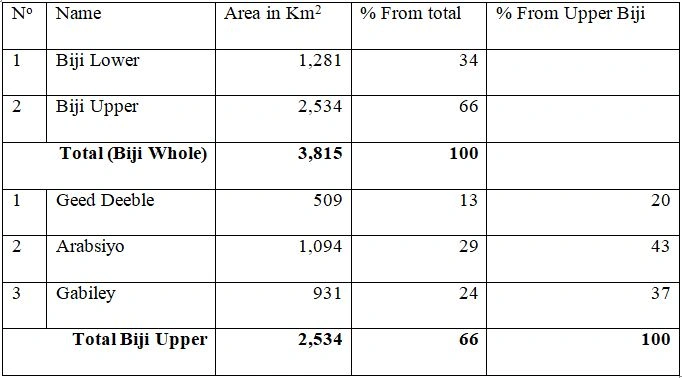
Table 1: Biji whole, Upper and Pilot Areas in Km2
The Togga Biji catchment is one of the main water sources for Hargeisa, the capital city of the Waqooyi-Galbeed region. It has three crucial sub-catchment areas: Gabiley, Arabsiyo, and Geed Deeble. The Geed Deeble well fields receive most of Hargeisa's water supply and a few shallow wells in the upper Biji water catchment. In the Wahen catchment area, more shallow wells have been installed.
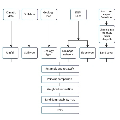
Figure 5: Flowchart of generating map suitability of dam construction
References
Copernicus 2021. Global Land Cover.
Dortaj, A., Maghsoudy, S., Doulati Ardejani, F. & Eskandari, Z. 2020. A hybrid multi-criteria decision making method for site selection of subsurface dams in semi-arid region of Iran. Groundwater for Sustainable Development. (10). pp. 100284.
Earth Map 2021. What is Earth Map?
FAO 2021. FAO/UNESCO Soil Map of the World. 2021.
Giz 2015. Sustainable land management in “Somaliland”, Somalia. 2015.
Ibrahim, G.R.F., Rasul, A., Ali Hamid, A., Ali, Z.F. & Dewana, A.A. 2019. Suitable Site Selection for Rainwater Harvesting and Storage Case Study Using Dohuk Governorate. Water. (11)4,. pp. 864.
Mugo, G.M. & Odera, P.A. 2019. Site selection for rainwater harvesting structures in Kiambu County-Kenya. The Egyptian Journal of Remote Sensing and Space Science. (22)2,. pp. 155–164.
Njiru, F.M. & Siriba, D.N. 2018. Site Selection for an Earth Dam in Mbeere North, Embu County—Kenya. Journal of Geoscience and Environment Protection. (06)07,. pp. 113–133.
Noori, A., Bonakdari, H., Morovati, K. & Gharabaghi, B. 2018. The optimal dam site selection using a group decision-making method through fuzzy TOPSIS model. Environment Systems and Decisions. (38)4,. pp. 471–488.
Nzotcha, U., Kenfack, J. & Blanche Manjia, M. 2019. Integrated multi-criteria decision making methodology for pumped hydro-energy storage plant site selection from a sustainable development perspective with an application. Renewable and Sustainable Energy Reviews. (112). pp. 930–947.
Shahzad, U. 2021. Assessing, Mapping and Optimizing the Potential Dam Site Selection Using ArcGIS. Hydrology and water Resource. pp. 81.
USGS 2021a. Enter Search Criteria.
USGS 2021b. World Geologic Maps.
Yildirim, V., Memisoglu, T., Bediroglu, S. & Colak, H.E. 2018. Municipal Solid Waste Landfill Site Selection Using Multi-Criteria Decision Making and Gis: Case Study of Bursa Province. Journal of Environmental Engineering and Landscape Management. (26)2,. pp. 107–119.
Related Services
Our academic writing and marking services can help you!
Study Resources
Free resources to assist you with your university studies!