
- / Title
GIS-Based Modelling of Urban Heat Island Mitigation Through Green Infrastructure Design
Info: GIS-Based Modelling of Urban Heat Island Mitigation Through Green Infrastructure Design | phdassistance.com
Published: 3rd September 2026 inGIS-Based Modelling of Urban Heat Island Mitigation Through Green Infrastructure Design | phdassistance.com
Share this:
Related Services
Introduction
Urban heat islands (UHIs) play an increasingly crucial role in urban planning for climate resilience, especially due to changes in land cover, vegetation, buildings, and surface temperatures caused by urbanisation. GIS, remote sensing, digital twins, spatial models, and artificial intelligence create new possibilities for studying this complex phenomenon.
The following five proposed PhD research directions address distinct gaps in urban heat mitigation, focusing on digital-twin optimisation, spatial vulnerability, cross-scale thermal assessment, vegetation–urban morphology interactions, and AI-based thermal forecasting.
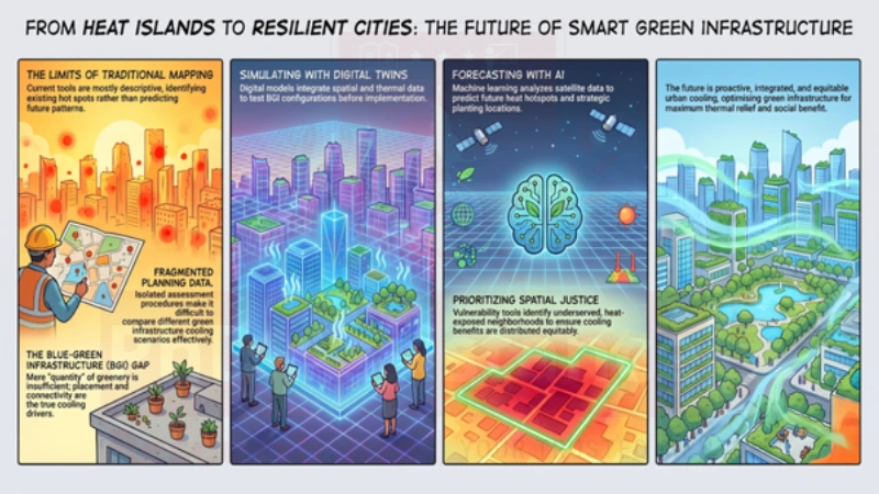
Proposed PhD Title 1: Digital Twin–Enabled Spatial Optimisation of Blue–Green Landscapes for Climate-Resilient Cities
Climate-resilient urban design has seen the emergence of urban heat islands as a major concern due to increased urbanisation, which changes surface energy balance. The blue-green infrastructure (BGI), consisting of such features as parks, vegetated corridors, green roofs and water elements, provides cooling through shading, evapotranspiration, plant density and connectivity. Assessment of such measures typically involves different approaches such as satellite remote sensing, modelling, and field measurements. Budzik, Sylla & Kowalczyk (2025) note that varying spatial resolution, modelling scale, boundaries of BGI and cooling metrics result in inconsistency of assessments. Further, they point out methodological integration and digital twin technology as two key future trends in the domain of BGI planning. Thus, the present study will focus on how digital models of the city environment could combine spatial, thermal, environmental and infrastructural aspects to facilitate optimisation of blue-green landscape scenarios. Thus, GIS urban heat island modelling can provide a spatial framework for integrating digital representations of the urban environment.
Problem Statement:
Existing planning processes for BGI usually make use of spatial databases that are not unified and assessment procedures that are isolated from each other; this makes comparative evaluation of different scenarios of interventions very problematic. Moreover, disparities in spatial resolution, scale of modelling, BGI boundaries and cooling metrics may result in inconsistent results. Lack of an integrated digital model hinders simulations and optimisation of BGI configuration.
Research Gap:
Existing approaches often analyse thermal, land-use, vegetation and infrastructure data separately, making it difficult to integrate heterogeneous spatial datasets within a unified representation of the urban environment. There is a need for a digital-twin-based framework that can integrate these data, simulate alternative blue–green infrastructure scenarios, and compare their thermal performance to support spatial optimisation of climate-resilient urban landscapes.
Research Question:
How can digital twin technology integrate spatial and environmental data to optimise blue–green landscape configurations for urban heat mitigation?
Outcome:
The study will produce a framework for digital twins that will be able to model the performance of BGI configurations. The study will develop a digital-twin framework for simulating alternative blue–green infrastructure configurations, comparing their thermal performance, and identifying spatially optimised interventions.
Reference:
Budzik, G., Sylla, M., & Kowalczyk, T. (2025). Understanding urban cooling of blue–green infrastructure: A review of spatial data and sustainable planning optimization methods for mitigating urban heat islands. Sustainability, 17, 142.
Proposed PhD Title 2. Spatial Justice and Heat Vulnerability: Prioritising Vegetated Urban Interventions for Underserved Neighbourhoods
Mitigation of urban heat is a concern not only for thermal planning, but also for spatial justice. Urban heat island PhD research increasingly considers how heat exposure and cooling benefits vary across different communities. Through shade, evaporation, changes in surface albedo, and ventilation, green infrastructure can help mitigate heat effects; however, these effects may not be equally distributed among urban residents. Lin & Li (2025) surveyed various types of urban green spaces, including parks, green roofs, street trees, vertical gardens, and community gardens, and noted that the cooling effects of each of these are contingent upon the level of vegetation cover, spatial configuration, urban form, and intervention type. Equitable distribution of green infrastructure and targeting heat-vulnerable populations and communities as research priorities are identified in the literature as well. Filling this research gap, this project aims to identify locations for the implementation of vegetated interventions based on heat exposure and vulnerability of population.
Problem Statement:
Current green-space planning could minimise urban heat exposure while failing to consider the unequal distribution of both thermal risk and green infrastructure access among various populations. Heat-exposed and disadvantaged communities might be subject to higher heat exposure rates and lower access to cooling facilities. In the absence of consideration of both thermal risk and green space access, planning might miss its target groups.
Research Gap:
Existing studies often examine thermal exposure, green-space accessibility and social vulnerability separately. A multi-dimensional spatial vulnerability assessment that integrates thermal exposure, environmental conditions, green-space accessibility and population characteristics remains insufficiently developed. Such an approach could identify where heat risk and limited access to cooling infrastructure overlap and support more equitable prioritisation of green interventions.
Research question:
How can spatial vulnerability assessment identify priority locations for equitable green infrastructure deployment in heat-exposed communities?
Outcome:
The study will develop a geographical prioritisation tool that locates heat vulnerability and green space deficit to inform interventions. This will develop site-specific approaches to direct vegetation and green spaces towards communities that are more exposed to heat and environmental disadvantages.
Reference:
Lin, H., & Li, X. (2025). The role of urban green spaces in mitigating the urban heat island effect: A systematic review from the perspective of types and mechanisms. Sustainability, 17, 6132.
Proposed PhD Title 3. Cross-Scale Thermal Performance Assessment of Vegetation Configurations from Streetscapes to Metropolitan Regions
The efficiency of green infrastructure is influenced by both the attributes of the GI itself and the scale of analysis of its cooling effects. Depending on the scale of analysis, street trees, green roofs, parks, and more extensive vegetated systems can create different kinds of thermal impacts on streets, neighbourhoods, cities, and regions. As Khalili, Kumar, and Jones (2024) point out, the current approaches to GI evaluation function at various spatiotemporal scales and employ a variety of criteria, making it hard to compare the results. In addition, there is an identified gap in knowledge related to integrated assessment across different scales, as well as disagreement about the choice of indicators of thermal comfort. The recommendation for selecting a methodology depending on research purposes, context, and available data could be considered a basis for further development of a cross-scale approach to vegetation configuration and cooling efficiency analysis.
Problem Statement:
The thermal efficiency of green infrastructure may differ significantly based on the scale of investigation, methodology, and measures applied. The current literature often analyses individual streets, neighbourhoods, and large urban areas independently; thus, comparison across different scales becomes challenging. Differences in spatial and temporal resolution, in turn, may impact results related to cooling efficiency. A standardised approach should be established to find out how the efficiency of vegetation varies at different scales.
Research Gap:
Existing studies assess vegetation-related thermal performance at different spatial scales using diverse methods, indicators and datasets, making direct comparison difficult. There is a need for a cross-scale comparative framework that applies consistent thermal-performance indicators to evaluate vegetation configurations from streetscapes and neighbourhoods to metropolitan regions. Such a framework could identify how vegetation configuration and cooling performance change across spatial scales.
Research Question:
How does spatial scale influence the measured thermal performance of different vegetation configurations across urban environments?
Outcome:
The research will develop an assessment framework for vegetation across street, neighbourhood, and metropolis scales. It will explore scale-dependent indicators of thermality and the impact of vegetation configuration on cooling performance at these different scales.
Reference:
Khalili, S., Kumar, P., & Jones, L. (2024). Evaluating the benefits of urban green infrastructure: Methods, indicators, and gaps. Heliyon, 10, e38446.
Proposed PhD Title 4. Morphological Complexity, Building Density and Vegetative Geometry: Unravelling Their Influence on Local Thermal Regulation
Thermal conditions in urban areas are significantly affected by the interaction of the structural elements of the vegetation and the built environment. Features such as vegetation density, foliation structure, connectivity, building density, and landscape geometry can affect shading, air movement, evaporation, and heat transfer. Green infrastructure urban heat mitigation therefore requires consideration of not only vegetation quantity but also its spatial configuration and relationship with surrounding built form. In their article, Budzik, Sylla, and Kowalczyk (2025) consider the geometry of BGI to be an open problem requiring more investigation of how urban form affects cooling properties, considering the effects on building density and the park-breeze effect. In the same way, Lin and Li (2025) state that the density and distribution of the vegetation affect the cooling properties of various kinds of green space. Thus, increasing the amount of vegetation alone does not maximise the thermal effect. The geometric arrangement and relations between vegetation and built form need to be explored systematically. Urban heat island GIS analysis can help systematically examine the spatial relationships between vegetation configuration, built form, and thermal conditions to identify more effective urban design strategies.
Problem Statement:
Urban vegetation is often analysed with the help of rather elementary indicators such as percentage of vegetation cover or total vegetation area, whereas the impact of geometrical complexity, distribution of vegetation, building density, and connectivity of spaces has not been measured systematically. Such features can affect thermal processes in diverse ways. In turn, an increase in vegetation amount does not necessarily mean optimal thermal behaviour.
Research Gap:
Past studies have shown that there is an influence of vegetative properties on urban thermal behaviour; however, the effects of vegetative shape, spatial complexity, density of buildings, and the morphology of urban form have not been quantitatively defined. Budzik et al. (2025) particularly note the need for more study on the BGI shape complexity and the interaction of the BGI with urban morphology. Thus, the connection between the configuration of vegetation and built form needs further study.
Research Question:
How do vegetation geometry and surrounding urban morphology interact to influence local thermal regulation?
Outcome:
This study will examine the relationships between vegetation geometry, urban morphology, and local thermal conditions. It will define the properties of configurations that provide more cooling effect and create evidence-based design guidelines for arranging vegetation in cities.
Reference:
Budzik, G., Sylla, M., & Kowalczyk, T. (2025). Understanding urban cooling of blue–green infrastructure: A review of spatial data and sustainable planning optimization methods for mitigating urban heat islands. Sustainability, 17, 142.
Proposed PhD Title 5. Artificial Intelligence for Satellite-Derived Thermal Forecasting and Strategic Vegetation Placement in Future Climate Scenarios[
Remote sensing provides valuable information on the spatial patterns of thermal conditions, vegetation, and areas exposed to higher temperatures. The emergence of new techniques of artificial intelligence and machine learning enables an opportunity to shift from retrospective mapping to predictive analysis of urban climate. According to Lin & Li (2025), the combination of remote sensing and GIS technologies can find optimal places for greenery installation, whereas the combination of AI and machine learning together with remote sensing would enable the prediction of future tendencies of UHI development. Furthermore, it is essential to mention evidence-based green infrastructure planning for diverse climatic and urban regions, which is pointed out by the same authors in their review. At the same time, according to Teo et al. (2022), it is possible to apply ArcGIS technology for analysing the connection between greenery and temperature distribution through the collection of data concerning temperatures, greenery, buildings, and space.
Problem Statement:
The traditional use of remote sensing and geographic information systems is mostly descriptive when it comes to depicting the current thermal state and locating existing heat hotspots, offering little scope for predicting the heat patterns in the future. Even though satellite imagery could help us understand the connection between vegetation and temperature, urban planning requires a more proactive approach for predicting future heat-prone locations.
Research Gap:
The use of remote sensing and GIS technology in mapping existing UHI trends and examining relationships between plant life and temperatures has become increasingly common. However, its use in predicting future conditions and the placement of interventions is relatively underexplored. According to Lin and Li (2025), the combination of artificial intelligence and machine learning with remote sensing offers potential in this regard.
Research Question:
How can AI-based analysis of satellite-derived environmental data forecast future urban heat hotspots under different climate scenarios and optimise the spatial placement of vegetation interventions?
Outcome:
This research will develop an AI-assisted spatial forecasting model that will predict heat-prone areas using environmental variables derived through satellite imagery. This model will create prioritised maps for planting vegetation to inform proactive climate adaptation and landscape planning.
Reference:
Lin, H., & Li, X. (2025). The role of urban green spaces in mitigating the urban heat island effect: A systematic review from the perspective of types and mechanisms. Sustainability, 17, 6132.
Need assistance finalising your Green infrastructure dissertation title? Developing a strong research direction around spatial thermal modelling, green infrastructure optimisation, urban morphology, heat vulnerability, and climate-resilient planning can be challenging—but you don’t have to do it alone.
Our research consultants can help refine your ideas, identify literature gaps, and guide you toward a topic that aligns with current academic trends and your programme requirements.
Contact us to begin one-on-one topic development and refinement with PhdAssistance.com Research Lab.
FAQs:
- How can GIS be used to model urban heat islands?
GIS can integrate land surface temperature, land use/land cover, vegetation, building density, and other spatial datasets to identify heat hotspots and analyse their relationship with urban characteristics. - How does green infrastructure mitigate urban heat islands?
Green infrastructure reduces heat through shading, evapotranspiration, albedo modification, and improved airflow. Its effectiveness depends on vegetation type, density, spatial arrangement, and surrounding urban form. - How to assess urban heat island mitigation using GIS?
UHI mitigation can be assessed by comparing temperature patterns with green-space distribution and modelling different intervention scenarios. GIS can help identify priority locations and estimate potential cooling effects. - What GIS methods are used for urban heat island analysis?
Common approaches include remote-sensing-based land surface temperature mapping, spatial overlay, buffer analysis, land-use classification, hotspot analysis, spatial statistics, and GIS-based suitability modelling. - How can GIS help optimise green infrastructure for UHI mitigation?
GIS can combine thermal, vegetation, land-use, building, and vulnerability data to identify suitable intervention locations and compare alternative green infrastructure configurations for targeted heat reduction.
Share this:
Cite this work
APA
PhD Assistance. (n.d.). GIS-based modelling of urban heat island mitigation through green infrastructure design. Retrieved August 20, 2026, from PhD Assistance
MLA
PhD Assistance. “GIS-Based Modelling of Urban Heat Island Mitigation Through Green Infrastructure Design.” PhD Assistance, n.d. Web. 20 Aug. 2026.
MLA 7
PhD Assistance. “GIS-Based Modelling of Urban Heat Island Mitigation Through Green Infrastructure Design.” PhD Assistance. Web. 20 Aug. 2026.
Harvard
PhD Assistance (n.d.) GIS-Based Modelling of Urban Heat Island Mitigation Through Green Infrastructure Design. Available at: https://www.phdassistance.com/title/urban-heat-island-mitigation/ (Accessed: 20 August 2026).
Vancouver
PhD Assistance. GIS-Based Modelling of Urban Heat Island Mitigation Through Green Infrastructure Design [Internet]. [cited 2026 Aug 20]. Available from: https://www.phdassistance.com/title/urban-heat-island-mitigation/
Wikipedia
PhD Assistance. “GIS-Based Modelling of Urban Heat Island Mitigation Through Green Infrastructure Design.” PhD Assistance. Retrieved August 20, 2026, from https://www.phdassistance.com/title/urban-heat-island-mitigation/
OSCOLA
PhD Assistance, ‘GIS-Based Modelling of Urban Heat Island Mitigation Through Green Infrastructure Design’ (PhD Assistance, n.d.) https://www.phdassistance.com/title/urban-heat-island-mitigation/ accessed 20 August 2026.
Study Resources
Free resources to assist you with your university studies!