
Predictive Modelling of Coastal Flood Risk Under Sea-Level Rise Scenarios for Urban Infrastructure Planning
Info: Predictive Modelling of Coastal Flood Risk Under Sea-Level Rise Scenarios for Urban Infrastructure Planning Topics I phdassistance.com
Published: 4th September in Predictive Modelling of Coastal Flood Risk Under Sea-Level Rise Scenarios for Urban Infrastructure Planning Topics I phdassistance.com
Share this:
Related Services
Our academic writing and marking services can help you
Introduction
Climate Change and Coastal Urbanization have contributed to the need for efficient tools for flood risk assessment and prediction. Sea-level rise, intense rainfall, storm surges, tidal movements, and inadequate drainage can interact to create complex flooding conditions, and this is a threat to buildings, transport, and infrastructure. Conventional flood risk assessments are constrained by the limitation of considering only one hazard at once and simple scenario generation, and this is not entirely sufficient. With the growth of coastal cities, Coastal Flood Risk Predictive Modelling will help in assessing vulnerabilities and impacts on infrastructure.
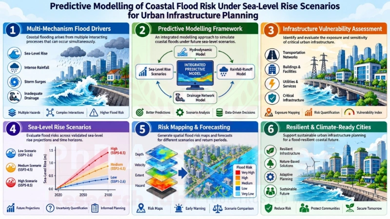
Proposed PhD Topic 1: Multi-Mechanism Predictive Framework for Assessing Sea-Level Rise Impacts on Urban Infrastructure
Background Context:
Urban areas in coastal zones are becoming vulnerable to floods due to rising sea levels, population growth, and infrastructure located in low-lying areas. According to Habel et al. (2020), floods in coastal areas cannot be viewed solely as seawater flooding; they can also result from groundwater flooding and storm drain backflow. In their study, the researchers found that these processes can occur concurrently and pose an additional risk to urban buildings, drainage systems, and critical infrastructure. With ongoing rising sea levels, such concurrent flooding processes may become more common. However, most studies consider only one flood mechanism at a time. An integrated prediction approach would thus help develop a Coastal Flood Risk Assessment Framework for infrastructure planning considering various sea-level rises.
PhD-Level Verification:
Habel et al. (2020) strongly support multi-mechanism analysis of flooding. However, the method proposed by Habel et al. (2020) works only in a particular coastal urban setting. It is still necessary to develop a general predictive method that could incorporate multiple mechanisms of flooding in various urban environments under different Sea-Level Rise Scenarios. The task represents an excellent topic for PhD-level research work.
Research Questions:
Contributions at the PhD-Level:
Suggested Readings:
Habel, S., Fletcher, C. H., Anderson, T. R., & Thompson, P. R. (2020). Sea-level rise induced multi-mechanism flooding and contribution to urban infrastructure failure. Scientific Reports, 10, 3796. https://doi.org/10.1038/s41598-020-60762-4
Proposed PhD Topic 2: Probabilistic Compound Flood Prediction Under Future Sea-Level and Precipitation Conditions
Background Context:
Coastal flooding has become quite complicated due to the combination of sea-level rise, heavy precipitation, tides, and limitations in the drainage system in such urban environments. Obara et al. (2025) have shown that the combination of precipitation may significantly exacerbate the failures of the drainage system under future conditions associated with sea-level rise. It was shown by Obara et al. (2025) in the Waikīkī case study that the combination of sea-level rise and precipitation caused much more extensive flooding than sea-level rise only. However, despite being significant, the above results only present a partially effective way of measuring uncertainties of the frequency, timing, intensity, and concurrence of compound flood hazards, since varying combinations of rainfall rates, storm durations, tides, and future sea level rise might cause various effects on infrastructure. Thus, creating a probability-based Coastal Flood Prediction model would enhance the process of modeling compound floods and allow for obtaining more precise Predictive Flood Modelling for urban infrastructure planning.
PhD-Level Verification:
However, Obara et al. (2025) provide an example of the significance of combining rainfall and sea-level rise, but it is limited to one drainage system and deterministic scenario analysis. There is still a need for research on probabilistic modelling of compound-flood occurrence under varying future conditions of compound flooding under various conditions in the future. Such studies could be beneficial for Predictive Flood Modeling.
Research Questions:
PhD-Level Contributions:
Suggested Readings:
Habel, S., Fletcher, C. H., Anderson, T. R., & Thompson, P. R. (2020). Sea-level rise-induced multi-mechanism flooding and contribution to urban infrastructure failure. Scientific Reports, 10, 3796. https://doi.org/10.1038/s41598-020-60762-4.
Proposed Dissertation topic 3: Dynamic Coastal Flood Prediction for Climate-Resilient Transportation Infrastructure
Background Context:
Transportation systems are especially susceptible to coastal flooding due to the placement of transport routes and their supporting infrastructure in lower-lying urban regions. Shen et al. introduced a methodology for integrated modeling of rain events, storm tides, ocean dynamics, and urban drainage for transportation systems in Norfolk, Virginia, under present-day and future climate conditions. It was found that the significance of various types of flooding is changing in the future, with tidal flooding gaining importance due to rising sea level. The research also demonstrates discrepancies between dynamic modelling and the “bathtub” approach. The results of the work call for the development of Advanced Urban Flood Risk Modelling for realistic representation of complex flooding scenarios.
PhD Level Verification:
While Shen et al. illustrate the benefits of coupled dynamic flood modelling, the research is dependent on a certain case study and transport network. Predictive models that can be applied in various cities and transport networks by considering variations in rainfall, storm tides, and sea level need to be developed further. This can be done through a PhD study.
Research Questions:
Contributions at the PhD-Level:
Suggested Readings:
Shen, Y., Morsy, M. M., Huxley, C., Tahvildari, N., & Goodall, J. L. (2019). Flood risk assessment and increased resilience for coastal urban watersheds under the combined impact of storm tide and heavy rainfall. Journal of Hydrology, 579, 124159. https://doi.org/10.1016/j.jhydrol.2019.124159.
Proposed Dissertation Topic 4: Uncertainty-Aware Urban Flood Risk Modelling Using Multi-Source Data and Climate Scenarios
Background Context:
Coastal flood planning needs a comprehensive understanding of the risks involved and the exposure of people, structures, and other infrastructure to those risks. Rahman et al. (2026) devised a scenario-based method for Jeddah, which made use of sea level rise, storm surge, rainfall, wind, atmospheric pressure, topography, and nighttime lights data to determine the future flood exposure in the region. The scenario was developed considering the situation up to 2030, 2050, and 2100. The usefulness of incorporating several types of datasets in the analysis of urban floods is evident from this example. However, there are uncertainties in the predictions of climate change, elevation data, flood exposure indicators, and flood processes themselves. This calls for a more robust framework which is not only based on a scenario but also quantifies the uncertainties involved.
PhD-Level Verification:
This is evident through the findings of Rahman et al. (2026), which highlight the need for scenario-based data integration, especially in data-scarce coastal regions. Nonetheless, uncertainty regarding climate change forecasts, exposure data, land use change, and factors contributing to flooding warrants further research. For instance, a PhD study can come up with a probability model to integrate multi-source data and uncertainty analysis into future SLR scenarios.
Research Questions:
Contributions at the PhD-Level:
Suggested Readings:
Rahman, M., Benaafi, M., Rahman, S. M., Rahman, M., Patwary, A. I., & Aljundi, I. H. (2026). Scenario-driven data fusion for compound coastal flood risk and exposure assessment using night-time lights in Jeddah. Geomatics, Natural Hazards and Risk, 17(1), 2617002. https://doi.org/10.1080/19475705.2026.2617002
Proposed Dissertation Topic 5: Transferable Deep Learning Models for Coastal Flood Prediction Under Climate Adaptation Scenarios
Background Context:
The computational demands of physics-based flood models may hinder the ability to predict on large scales quickly, especially when it is necessary to consider multiple scenarios related to future climate changes and adaptation measures. Hassan et al. (2026) have created a lightweight CNN for predicting the depth of coastal floods for various scenarios of sea level rise and shoreline adaptation. The research was conducted in Abu Dhabi and San Francisco, and the authors reported that their model achieved improved prediction performance compared with other models than those obtained by other models. Thus, the potential of machine learning to generate predictions more quickly while considering future climate change and adaptation can be seen. At the same time, it should be noted that varying coast morphology, available data, and flood processes may influence model performance in other places.
PhD-Level Verification:
Hassan et al. (2026) have provided evidence that deep learning can provide efficient flood prediction in various settings. Nevertheless, there are still some issues related to the accessibility of the data, generalisability of the model, uncertainty, and performance in unknown climatic and adaptive scenarios. Thus, a PhD research project could be aimed at developing an uncertainty-aware Predictive Flood Modelling framework.
Research Questions:
Contributions at the PhD-Level:
Suggested Readings:
Need assistance finalising your coastal flood risk dissertation topic? Developing a strong, researchable topic around predictive flood modelling, sea-level rise, climate scenarios, or resilient urban infrastructure can be challenging — but you don’t have to do it alone.
Our research consultants can help refine your ideas, identify literature gaps, and guide you toward a topic that aligns with current academic trends and your programme requirements.
Contact us to begin one-on-one topic development and refinement with PhdAssistance.com Research Lab.
FAQs:
- How can coastal flood risk be predicted under sea-level rise scenarios?
Coastal flood risk can be predicted by combining sea-level rise projections with rainfall, tides, storm surges, drainage, terrain, and infrastructure data to model future flood conditions. - How does sea-level rise affect coastal flood risk?
Sea-level rise increases baseline water levels and can intensify flooding caused by rainfall, tides, storm surges, groundwater, and drainage-system backflow in coastal cities. - What is compound coastal flooding?
Compound coastal flooding occurs when multiple flooding mechanisms, such as heavy rainfall, tides, storm surges, and sea-level rise, interact and increase overall flood impacts. - Can AI improve coastal flood prediction?
AI and deep-learning models can provide faster flood predictions and help assess different sea-level rise, climate, and adaptation scenarios across coastal environments. - Why is uncertainty important in flood risk modelling?
Uncertainty modelling accounts for variations in climate projections, terrain data, infrastructure exposure, and future flood conditions, supporting more reliable planning decisions.
Share this:
Cite this work
PhD Assistance. (n.d.). Predictive modelling of coastal flood risk under sea-level rise scenarios for urban infrastructure planning. Retrieved September 1, 2026, from PhD Assistance.
PhD Assistance. “Predictive Modelling of Coastal Flood Risk Under Sea-Level Rise Scenarios for Urban Infrastructure Planning.” PhD Assistance, n.d. Web. 1 Sept. 2026.
PhD Assistance. “Predictive Modelling of Coastal Flood Risk Under Sea-Level Rise Scenarios for Urban Infrastructure Planning.” PhD Assistance. Web. 1 Sept. 2026.
PhD Assistance (n.d.) Predictive Modelling of Coastal Flood Risk Under Sea-Level Rise Scenarios for Urban Infrastructure Planning. Available at: https://www.phdassistance.com/topic/coastal-flood-risk-predictive-modelling (Accessed: 1 September 2026).
PhD Assistance. Predictive Modelling of Coastal Flood Risk Under Sea-Level Rise Scenarios for Urban Infrastructure Planning [Internet]. [cited 2026 Sep 1]. Available from: https://www.phdassistance.com/topic/coastal-flood-risk-predictive-modelling
PhD Assistance. “Predictive Modelling of Coastal Flood Risk Under Sea-Level Rise Scenarios for Urban Infrastructure Planning.” PhD Assistance. Retrieved September 1, 2026, from https://www.phdassistance.com/topic/coastal-flood-risk-predictive-modelling
PhD Assistance, ‘Predictive Modelling of Coastal Flood Risk Under Sea-Level Rise Scenarios for Urban Infrastructure Planning’ (PhD Assistance, n.d.) https://www.phdassistance.com/topic/coastal-flood-risk-predictive-modelling accessed 1 September 2026.
Study Resources
Free resources to assist you with your university studies!